.png)

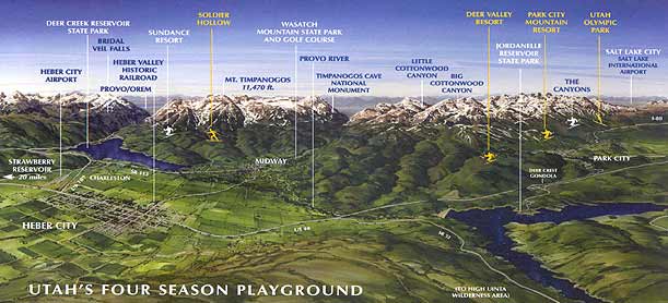
Heber Valley Map
HEBER VALLEY
 CITY INFORMATION:
75 North Main, Heber City
(435) 654-0757
http://www.ci.heber.ut.us/
COUNTY INFORMATION:
475 North Main Street, Heber City
(435) 654-3666
http://www.gohebervalley.com/Contact-Us
SCHOOL INFORMATION:
101 East 200 North, Heber City
(435) 654-0280
www.wasatch.edu
Heber City is a city in Wasatch County, Utah, United States. The population was 7,297 at the 2000 census. Heber City was founded by English emigrants who were members of The Church of Jesus Christ of Latter-day Saints in the late 1840s, and is named after the Mormon apostle Heber C. Kimball. It is the county seat of Wasatch County. The city was largely pastoral, focusing largely on dairy farms and cattle ranching, and has since become a bedroom community for Orem, Provo, Park City and Salt Lake City.
Heber City is currently governed by Mayor David Phillips along with City Council Members Jeffery Bradshaw, Elizabeth Hokanson, Nile Horner, Robert Patterson, and Eric Straddeck.
Within the city limits are Heber Valley and J.R. Smith Elementary Schools, Timpanogos Intermediate School, the newly built Wasatch High School, and Wasatch Alternative High School. Additional schools in the Heber Valley are Midway and Old Mill Elementary Schools, and Rocky Mountain Middle School. All of these schools are part of the Wasatch County School District. Utah Valley University maintains a secondary campus of north of Heber City along the US-40 corridor.
Heber City supports four LDS stakes, as well as congregations of Southern Baptists, Catholics as part of the Diocese of Salt Lake City, and Jehovah's Witnesses. Heber City was first settled in 1859 by Robert Broadhead, James Davis and James Gurr. John W. Witt built the first house in the area. The area was under the direction of BishopSilas Smith who was in Provo. In 1860 Joseph S. Murdock became the bishop over the Latter-day Saints in Heber City and vicinity.
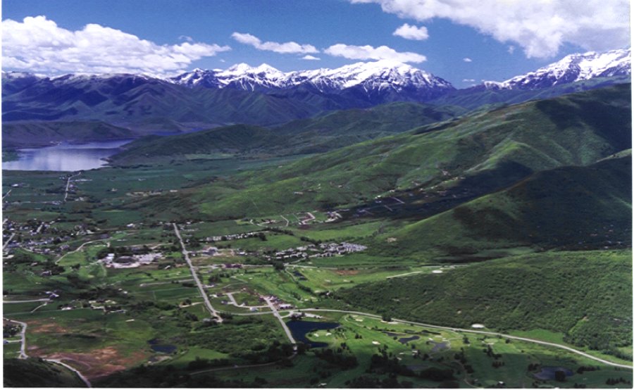
Geography of Heber
Heber City is located at (40.506793, -111.412292), at an elevation of 5595 feet.
According to the United States Census Bureau, the city has a total area of 3.5 square miles (8.9Â km2), all of it land.
Heber City is in the neighborhood of three large reservoirs, Jordanelle, Deer Creek, and Strawberry.
Economy
Heber has seen the fastest-growing economy and has one of the lowest unemployment rates in Utah. Local developers and business leaders cite that there are not enough jobs in the city itself (as 27% of residents commute to Park City or Salt Lake City for work) and wish to improve the city's self-dependence. Average home prices in the valley doubled from 2002 - 2008 and the population has grown by 25% in that same time period.
Tourism is a year-round industry in the Heber Valley. The winter season features cross-country and downhill skiing on several trails and the nearby ski resorts of Park City. In the summer, golfing and other outdoor recreational activities are abundant. Heber is also home to the Heber Valley Historic Railroad (HVRR) also known as the Heber Creeper.
Heber City's youth are employed largely in the surrounding golf courses, restaurants, and specialty shops in Heber City and the surrounding area. The adult population work mostly in Park City, Salt Lake City, Provo and Orem. Skiing and Snowboarding is very popular among Heber City's youth, and many people go to Park City mountain resort, Canyons, or Deer Valley, all of which are in Park City. Farming was once a large force in the economy, but this has diminished slightly. The largest local employer is the Wasatch County School District.
Demographics Historical Populations
Census Pop. %
1860 471
1870 658 39.7%
1880 1,291 96.2%
1890 1,538 19.1%
1900 1,725 12.2%
1910 2,214 28.3%
1920 2,071 ÂÂ6.5%
1930 2,477 19.6%
1940 2,748 10.9%
1950 2,936 6.8%
1960 2,936 0%
1970 3,245 10.5%
1980 4,362 34.4%
1990 4,782 9.6%
2000 7,291 52.5%
As of the census of 2000, there were 7,291 people, 2,296 households, and 1,829 families residing in the city. The population density was 2,113.5 people per square mile (816.0/km2). There were 2,451 housing units at an average density of 710.5/sq mi (274.3/km2). The racial makeup of the city was 94.32% White, 0.05% African American, 0.44% Native American, 0.29% Asian, 0.07% Pacific Islander, 3.32% from other races, and 1.51% from two or more races. Hispanic or Latino of any race were 7.08% of the population.
There were 2,296 households out of which 48.5% had children under the age of 18 living with them, 66.3% were married couples living together, 9.5% had a female householder with no husband present, and 20.3% were non-families. 15.4% of all households were made up of individuals and 6.4% had someone living alone who was 65 years of age or older. The average household size was 3.16 and the average family size was 3.55.
In the city the population was spread out with 35.2% under the age of 18, 10.5% from 18 to 24, 31.1% from 25 to 44, 14.7% from 45 to 64, and 8.6% who were 65 years of age or older. The median age was 28 years. For every 100 females there were 102.0 males. For every 100 females age 18 and over, there were 97.6 males.
The median income for a household in the city was $45,394, and the median income for a family was $47,481. Males had a median income of $33,816 versus $21,524 for females. The per capita income for the city was $17,358. About 4.8% of families and 6.1% of the population were below the poverty line, including 6.7% of those under age 18 and 1.9% of those age 65 or older.
Transportation
U.S. Route 40 and U.S. Route 189 both cross the city. Interstate 80 is located approximately eighteen miles north of the city and can be accessed via Highway 40 while Interstate 15 can be accessed via Highway 189 through Provo Canyon and is approximately twenty-five miles away. A typical drive to downtown Salt Lake City is approximately forty five minutes to one hour.
Heber City was connected to Provo by a 32 mile long railroad line. The line, completed in 1899, was used by Denver & Rio Grande Westernuntil 1967. Today, a portion of the line is used by the famous Heber Valley Railroad, a heritage railroad open to the public.
The Heber City Municipal Airport is located to the south of the city, near the junction of U.S. Route 40 and U.S. Route 189, and is capable of handling small prop and jet traffic. During the winter ski season, and particularly the Sundance Film Festival, the airport is crowded with private aircraft as it is the closest airport to Park City. The airport is also home to the Heber Valley Airshow, held each summer. The nearest airport with commercial airline service is Salt Lake City International Airport.
References
^US Census Bureau 2007 Estimates www.census.gov
"American Fact Finder" United States Census Bureau. Retrieved 2008-01-31.
"US Board on Geographic Names" United States Geological Survey. 2007-10-25. Retrieved 2008-01-31.
^Jenson, Andrew, Encyclopedic History of the Church of Jesus Christ of Latter-day Saints, (Salt Lake City:Deseret News Press, 1941) p. 328
"US Gazetter Files: 1999 - 2000"United States Census Bureau. 2005-05-03. Retrieved 2008-01-31.
Deseret News - "Wasatch Back is Growing Fast" September 9, 2008.